Capel Curig
Capel Curig - Overview
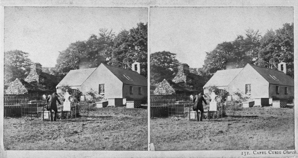
Capel Curig is located on Thomas Telford’s historic post road, today the A5. The small village is situation in a valley between the summit of Crimpiau to the north-east and the Llynau Mymbyr to the south-west. The origins of the village are not entirely clear, but archaeological excavations have found Roman bricks and cement, perhaps evidence of a small garrison, along the river Llugwy. The name Capel Curig is derived from the small sixth-century church founded here by the Celtic bishop, Saint Curig. Today this church is known as St Julitta’s Church.
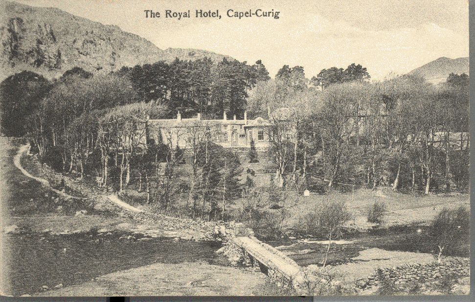
At the end of the eighteenth century, Richard Pennant built the first major road between Bangor and Capel Curig and, in 1801, set up the Capel Curig Inn, today renamed Plas y Brenin. A year later, Thomas Telford’s new road connecting Holyhead and London reached Capel Curig and from 1808 a steady stream of mail coaches brought many tourists into the valley.
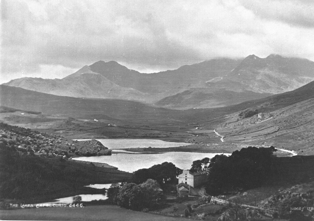
Situated beside two connected lakes and surrounded by the mountains of Snowdonia, the village’s location attracted anglers, landscape artists and mountaineers throughout the nineteenth century. During the 1850s, the German journalist and travel writer Julius von Rodenberg was intrigued by the British obsession with trout and salmon fishing in all kinds of weather as he observed fellow-tourists wade around the Llynau Mymbyr. Towards the end of the nineteenth century, the Italian painter Onorato Carlandi returned time and again to Capel Curig to sketch the landscape and watch his fellow artists walk around the area with large canvasses on their backs.
Capel Curig is home to a predominantly Welsh-speaking community and remains a favourite stop for mountaineers and kayakers.
Accounts of Travel
Reise durch England, Wales und Schottland im Jahre 1817, 1816
Samuel Heinrich Spiker (1786 – 1858)
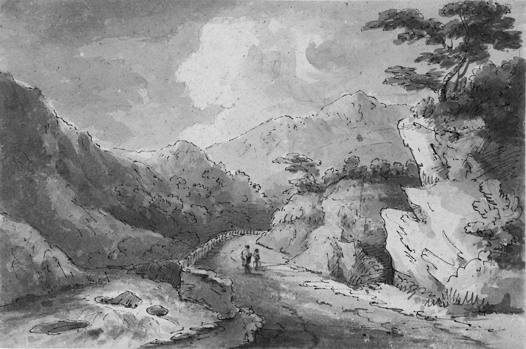
Capel-Cerrig, ein kleiner Ort, aus wenigen Bauerhäusern und einer Kapelle bestehend, wird durch seine romantische Lage, nicht weit vom Fusse des Snowdon, des höchsten Berges in Wales, bedeutend. Eine große Wohlthat ist den Reisenden dadurch erwiesen worden, daß Lord Penrhyn, dessen wir oben erwähnt haben, in dem selben einen großen Gasthof erbauen lassen, wo man sich nach der beschwerlichen Fahrt durch das Thal erholen kann. Das Gebäude ist nach den Zeichnungen Wyatts, des Architekten, aufgeführt worden, aber keinesweges einer seiner Meisterstücke. Das Ganze besteht aus einem Hause von 3, und einem von 2 Stockwerken, dicht aneinander, welches letztere wiederum in zwei Abtheilungen zerfällt, von denen die eine mit einer Thür im gothischen, die andere mit einer im gewöhnlichen Stile versehen ist. Wir wurden in ein niedliches kleines sechsecktes Cabinet, nach hinten heraus, geführt, dessen Fenster auf den Garten gingen, und vergaßen bald, über die schöne Aussicht, deren wir hier aus den Fenstern genossen, was wir gegen das Gebäude selbst einzuwenden gehabt hatten. Man muß indeß nicht erwarten, hier einen weiten Blick in das Land thun zu können; denn die Aussicht wird durch ein Gebirge begränzt, das sich in einer geringen Entfernung vor dem Hause erhebt, aber durch sein allmähliges terrassenartiges Aufsteigen, und durch das herrliche, üppige Buschwerk, mit dem es, beinahe bis zum Gipfel, bedeckt ist, dennoch für das Auge viel Malerisches erhält. Der Garten (welcher die ganze Länge des Hauses, das wir bewohnten, einnimmt, und das aus dem so eben erwähnten Cabinette und zwei viereckten Vorsprüngen besteht, die durch Zwischengebäude mit ihm verbunden sind) ist zwar sehr schmal, und enthält nur einen Kiesgang mit einigen Blumenbeeten zu beiden Seiten, gewinnt aber durch seine Länge und die Anpflanzung von wilden Lorbeern, wilden Rosen u. dergl. sehr. – Die Aussicht auf die umliegende Gegend, und namentlich nach Westen zu, zu genießen, muß man vor das Haus gehen und eine gegenüberliegende Anhöhe ersteigen. Hier entfaltet sich ganz die wilde Schönheit der Gegend: überall nichts als Klippen und Schluchten: gegen Westen die beiden kleinen Seen, welche am Fuße des Snowdon, nicht weit von einander, liegen, und über ihnen der dunkele Snowdon selbst, mit seinen zwei dicht neben einander emporstarrenden Spitzen! Ihm zur Linken erhebt sich der Moel Siabod mit seinen drei Zacken, und an diesen schließen sich, in allmähliger Abstufung, die Berge an, welche endlich die Wand hinter dem Gasthofe bilden. Dieser letztere ist übrigens, trotz seiner unzusammenhangenden Anlage, mit allen Bequemlichkeiten versehen, die man nur wünschen kann, ja es ist sogar für den wissenschaftlichen Reisenden gesorgt, indem auf dem Corridor, durch welchen das kleinere Haus mit dem größeren verbunden ist, ältere und neuere topo- und orographische Karten von Wales an den Wänden befestigt sind.
Capel Cerrig, a small place, consisting of a few peasants’ houses, and a chapel, becomes important from its romantic situation, not far from the foot of Snowden, the highest mountain in Wales. A great benefit has been conferred on travellers by Lord Penrhyn, whom we have already mentioned, by the large inn built by him at this place, where we can solace ourselves after the toilsome passage through the valley. This inn is built agreeably to a design of Mr. Wyatt, the architect, but is by no means one of his masterpieces. The whole consists of one house of three, and another of four stories in height, situated close to each other; the latter being again separated into two divisions, one of which has a gate in the Gothic style, and the other a gate in the common style. We were ushered into a pretty little hexangular room, in a projection behind the building, the windows of which opened into the garden, and in the contemplation of the beautiful prospect we here enjoyed, soon forgot all our objections to the building itself. It is not however to be supposed that we have here an extensive prospect, for the view is bounded by a mountain, rising at a small distance from the house. But the gradual terrace-like ascent, and the rich and beautiful brushwood with which it is covered almost to its very summit, have a very picturesque appearance. The garden, which runs along the whole length of the building in which we were, consisting of the projection already mentioned, and two other square projections connected together by intermediate structures, is indeed very narrow, and contains only a gravel walk with a few flower beds on each side, but from its length and the number of lauristinuses, roses, &c. with which it is filled, it has on the whole a very agreeable appearance. In order to enjoy the prospect of the surrounding country, and especially to the westward, we must ascend an eminence in front of the house. Here the country spreads itself out before us in all its wild beauty; in every direction we see nothing but rocks and ravines. To the west we perceive two little lakes at the foot of Snowden, not far from each other; and above them the dark Snowden itself, with its two closely approximating points. To the left of Snowden rises the Moel Siabod, with its three jagged points, and to these in regular gradation follow in a connected chain the mountains, which at length complete the wall behind the inn. This inn, notwithstanding its unconnected plan, is provided with every convenience a traveller can wish for. Nay, suitable provision is even made for the scientific tourist, as ancient and modern topographic and orographic maps of Wales are hung along the walls of the passage which connects the small house with the larger one.
(Travels through England, Wales and Scotland in the Year 1816. 2 vols. London: 1820)
England, Wales, Irland und Schottland, 1802
Christian August Gottlieb Göde (1774 – 1812)
In einer kleinen Entfernung über Capel Cerrig hinaus, wo das Thal sich in seiner ganzen Größe und Majestät darstellt, hat Lord Penrhyn einen sehr hübschen Gasthof erbauen lassen, der sich wie eine kleine gothische Kapelle ausnimmt. Er ist recht nett eingerichtet, und der dasige Wirth ist ein sehr gefälliger Mann. Wie mir dieser sagte, wird das romantische Thal gegenwärtig in den Sommermonaten häufig besucht. Nicht weit von diesem Hause liegt ein großer Teich. Wenn man bis dahin geht, so erblickt man den Snowdon mit seinem von Wolken bedeckten Haupte, welches noch über die näher stehenden, ungeheuern, schwarzen Felsen hervorragt.
Dies ist der schönste Standpunct im Thale von Capel Cerrig, dessen romantische Größe ich mit nichts ähnlichem zu vergleichen wüßte. Das Thal erscheint, von dieser Seite betrachtet, überall von Bergen eingeschlossen, und sein Hintergrund, der aus schwarzen Felsen bestehet, die dicht ineinander gedrängt dastehen mit ihren weißen Wolkenkränzen um die hohen Gipfel, die ausnehmende Größe ihrer Bildungen, die Abgeschiedenheit dieses rings um eingeschlossenen Thales, seine menschenleere Einsamkeit, seine Ruhe, die nicht einmal durch das Geräusch eines Stromes unterbrochen wird, denn der Wenol fließt in einiger Entfernung vorüber; dies alles vereiniget, macht es zu einem der wundervollsten und erhabensten Naturtempel.
Lange Zeit hat dieser Ort nur von Fußgängern besucht werden können, weil kein Fuhrweg über die Gebirge führte. Jetzt ist aber eine schöne Straße angelegt worden, die sich durch das ganze Thal, jedoch mehr westlich und mit einem Umwege von einer Meile nach Llanrwst hinzieht.
At a little distance from Capel Curig, where the valley presents itself in all its greatness and majesty, Lord Penrhyn has had a very pretty guesthouse built which presents itself as a small Gothic chapel. It is rather nicely furnished and the landlord is a very accommodating gentleman. As he told me, the romantic valley is at present much visited throughout the summer months. A large pond is situated not far from this house. Walking towards it, one can observe Snowdon with its cloud-topped summit peeping out from behind much closer monstrous black rocks.
This is the handsomest spot in the vale of Capel Curig whose romantic grandeur I cannot compare to anything similar. Viewed from this side, the valley appears everywhere surrounded by mountains. And its background, consisting of black mountains huddled together most tightly and their lofty summits crowned with white clouds, the exceptional magnitude of their shapes, the remoteness of the thoroughly enclosed vale, the deserted solitude, its calmness which, as the Wennol flows by at some distance, not even a burbling stream can disturb – all this combines into a most wonderful and sublime temple of nature.
For a long time, this spot could only be visited by pedestrians as no highway passed over the mountains. Now, however, a handsome new road has been laid which extends across the entire valley, but more towards the west and with a diversion of about a mile towards Llanrwst.
L’Europe pittoresque: pays du nord, c. 1880s
Jules Gourdault (1838 – 1912)
D’énormes rochers couchés ou debout le long d’un torrent qui va se jeter près de là dans le lac Sant-Peris forment l’encadrement de ce défilé, qui longe le village de Capel Curig et offre à sa partie supérieure un aspect de désolation lugubre. Non loin de là est le rocher dit le « Fort de Merlin » [Dinas Emrys], puis un autre lac, le Llyn Dinas, entouré d’un cercle de monts magnifiques, et, de l’autre côté du Snowdon, le pont romantique d’Aber-Glas-Lyn, qui a sa légende, comme le pic de l’Awen. Quand on se penchait autrefois sur sa rampe toute tapissée de lierre, on entendait sortir du fond de l’abîme un appel de détresse pareil à celui d’un homme qui se noie. Mais malheur au voyageur compatissant qui essayait de porter secours à l’être supposé en péril! Cette plainte n’était qu’un ruse de l’Esprit des eaux, une espèce de Loreley galloise qui attirait ainsi le passant pour l’entraîner dans le gouffre.
Enormous rocks lying or standing along the torrent that near here gushes into the Saint Peris lake are like a frame for this parade, that runs alongside the village of Capel Curig and lends a certain gloom and desolation to the upper parts. Not far from there is a rock known as ‘Merlin’s Fort’ [Dinas Emrys], then another lake, Dinas Lake, surrounded by a circle of magnificent mountains and, the other side of Snowdon, the romantic bridge at Aberglaslyn, which has its legend, just like the peak of Awen [inspiration]. In times past, when you leaned over its ivy-covered handrail, you would hear coming from the depths of the gulf a cry of distress like the cry of a drowning man. But woe betide the compassionate traveller who tried to help the being supposedly in trouble! This moan was nothing but a trick by the Spirit of the water, a sort of Welsh Loreley who attracted the passer-by in this way to drag him into the abyss.
Cardiff MSS on Microfilm: Snowdon, 1876 & 1879
J. Menard ( – )
Encore quelques kilomètres et nous voici à Capel Curig, un des plus beaux villages du district. Les maisons y sont élégantes, bien disposées pour procurer aux touristes le confortable et de ravissants points de vue, c’est un bon centre pour faire l’ascension de Shabod de Llewellyn de Glider Fach. Là on entre dans une vallée formée à gauche par Shabod et Glider Fach et au fond duquel serpente un torrent que nous allons longer jusqu’à Pen-y-Gwryd. Il tombe dans deux petits lacs appelés Mymbyr, et s’échappe du dernier pour grossir la Llugwy. A sa sortie du dernier lac il est traversé par un pont rustique d’où l’on a une des vues les plus grandioses de Snowdon. Supportée par Lliwedd à gauche et par Crib Goch à droite. On est encore à la distance d’environ 10 kilomètres du centre. Il était 5 heures quand nous arrivâmes à Pen y Gwryd. Nous y fûmes reçus très cordialement par nos hôtes Mr et Mme Owen.
A few more miles and here we are at Capel Curig, one of the most beautiful villages in the area. The houses are elegant, well positioned to provide tourists with comfort and delightful viewing points; it is a good base for climbing the Siabod of Llewellyn and Glyder Fach. There you enter a valley formed to the left by Siabod and Glider Fach and at the end of which meanders a torrent that we are going to follow as far as Pen-y-Gwryd. It falls into two little lakes called Mymbyr, and leaves the second to swell the Llugwy. Just where it leaves the last lake it is crossed by a rustic bridge which affords one of the most imposing views of Snowdon. Supported by Lliwedd to the left and Crib Goch to the right. We are still about 10 kilometres from the centre. It was 5 o’clock when we arrived at Pen-y-Gwryd where we were very warmly welcomed by our hosts Mr and Mrs Owen.